
Click here for District Infrastructure
Mahabub Nagar at a glance
The district has a total population of 30,77,050 persons (1991 Census). Mahabubnagar district has biggest rural population in A.P with 89 % of the population live in rural areas. Mahabubnagar district head quarter population is the smallest in A.P with 3.5 lakhs. The Scheduled Castes and Scheduled Tribes population of the district as per 1991 census is about 17% and 7.4% respectively.
The decennial growth rate of population of the district is 25.76% in comparison to 23.91% of the state between the period 1981 and 1991. The density (population per sq. km.) of the population of the district is 167 in relation to 241 in the state.
The sex ratio (females per 1000 males) in the district is 973 as per 1991 census.
The literacy rate (excluding 0-6 years age group) of the different group in the district according to 1991 census is in Table-1.
Table-1. Literacy rate in Mahabubnagar
| Persons | Males | Females | |
| Total | 29.58 | 40.80 | 18.03 |
| Rural | 25.22 | 36.29 | 13.87 |
| Urban | 63.33 | 75.16 | 50.79 |
Main languages spoken in the district are Telugu, Urdu and Hindi.
Approximately 90% of the population of the district are Hindus and 9% are Muslims.
In 1991, Mahabubnagar district comprised of 64 mandals. There are 11 towns and 1,545 villages (1476 inhabited villages and 69 uninhabited villages).
Mahabubnagar city Longitude - 077° 56' East, Latitude:16° 46' North
|
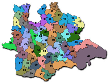
MANDALS OF MAHABUBNAGAR DISTRICT |
||||||||||||||||||||||||||||||||||||||||||||||||||||||||||||||||||||||||||||||||||||||||||||||||||||||||||||||||||||||||||||||||||||||||
|
|
||||||||||||||||||||||||||||||||||||||||||||||||||||||||||||||||||||||||||||||||||||||||||||||||||||||||||||||||||||||||||||||||||||||||
|
|
|
||||||||||||||||||||||||||||||||||||||||||||||||||||||||||||||||||||||||||||||||||||||||||||||||||||||||||||||||||||||||||||||||||||||
DISTRICT: MAHABUBNAGAR
Headquarters:
Mahabubnagar
| Unit | |||||||||||||||||||||||||||||||||||||||||||||||||||||||
| Area | Sq.km. | 18432.00 | Census 1991 | ||||||||||||||||||||||||||||||||||||||||||||||||||||
| Population | '000 | 3077.05 | " | ||||||||||||||||||||||||||||||||||||||||||||||||||||
| Male | '000 | 1559.62 | " | ||||||||||||||||||||||||||||||||||||||||||||||||||||
| Female | '000 | 1517.43 | " | ||||||||||||||||||||||||||||||||||||||||||||||||||||
| Urban | '000 | 342.19 | " | ||||||||||||||||||||||||||||||||||||||||||||||||||||
| Rural | '000 | 2734.86 | " | ||||||||||||||||||||||||||||||||||||||||||||||||||||
| Population Growth (p.a) | % | 2.59 | " | ||||||||||||||||||||||||||||||||||||||||||||||||||||
| Population Density (Person/Sq.Km) | Nos. | 167.00 | " | ||||||||||||||||||||||||||||||||||||||||||||||||||||
| Urbanisation | % | 11.12 | " | ||||||||||||||||||||||||||||||||||||||||||||||||||||
| Literacy | % | 29.58 | " | ||||||||||||||||||||||||||||||||||||||||||||||||||||
| Male | % | 40.80 | " | ||||||||||||||||||||||||||||||||||||||||||||||||||||
| Female | % | 18.03 | " | ||||||||||||||||||||||||||||||||||||||||||||||||||||
| Workers as % of total population | % | 50.20 | " | ||||||||||||||||||||||||||||||||||||||||||||||||||||
| Workers % of main Workers | |||||||||||||||||||||||||||||||||||||||||||||||||||||||
| Agriculture & allied activities | % | 83.40 | " | ||||||||||||||||||||||||||||||||||||||||||||||||||||
| Mining & Quarrying | % | 0.34 | " | ||||||||||||||||||||||||||||||||||||||||||||||||||||
| Mfg.(Non-household) industries | % | 3.56 | " | ||||||||||||||||||||||||||||||||||||||||||||||||||||
| Household industries | % | 1.86 | " | ||||||||||||||||||||||||||||||||||||||||||||||||||||
| Construction | % | 1.05 | " | ||||||||||||||||||||||||||||||||||||||||||||||||||||
| Services | % | 9.79 | " | ||||||||||||||||||||||||||||||||||||||||||||||||||||
| Forest Area as % of reporting area | % | 14.46 | 1997-98 | ||||||||||||||||||||||||||||||||||||||||||||||||||||
| Gross irrigated area as % of gross cropped area | % | 23.82 | " | ||||||||||||||||||||||||||||||||||||||||||||||||||||
| Value of output of major crops | |||||||||||||||||||||||||||||||||||||||||||||||||||||||
| Per capita food grain production | Kg. | 110.00 | " | ||||||||||||||||||||||||||||||||||||||||||||||||||||
| Road length per 100 sq.km. | Km. | 54.73 | 1996-97 | ||||||||||||||||||||||||||||||||||||||||||||||||||||
| Railway route length per 100 sq.km. | Km. | 0.57 | " | ||||||||||||||||||||||||||||||||||||||||||||||||||||
| Post offices per 100,000 persons | No. | 27.46 | " | ||||||||||||||||||||||||||||||||||||||||||||||||||||
| Bank branches per 100,000 persons | No. | 6.24 | 1994-95 | ||||||||||||||||||||||||||||||||||||||||||||||||||||
| Per capita bank deposits | Rs. | 1229.33 | " | ||||||||||||||||||||||||||||||||||||||||||||||||||||
| Per capita bank credit | Rs. | 893.58 | " | ||||||||||||||||||||||||||||||||||||||||||||||||||||
| Per capita bank credit to agriculture | Rs. | 423.23 | " | ||||||||||||||||||||||||||||||||||||||||||||||||||||
| Per ha. bank credit to agriculture | Rs. | 1868.00 | " | ||||||||||||||||||||||||||||||||||||||||||||||||||||
| Per capita bank credit to SSIs | Rs. | 41.34 | " | ||||||||||||||||||||||||||||||||||||||||||||||||||||
| Per capita bank credit to Industries | Rs. | 229.54 | " | ||||||||||||||||||||||||||||||||||||||||||||||||||||
|
|||||||||||||||||||||||||||||||||||||||||||||||||||||||
Source- Andhrapradesh.com
The district may be physiographically divided into more or less two distinct regions, the plains region with low lying scattered hills and the extensive Amarabad-Farhabad plateau, a continuous range of hills, of an average, elevation of about 800 meters, extending more or less, east-west along the Krishna river on the southern boundary of the district. The hill range is interspersed by several deep valleys, which are almost inaccessible from the plains.
The forests in this district are known to contain timber trees like bijasal (pterocarpus marsupiun), Nalla maddi (terminalia tomentosa), Eppa (Hardwickia binata), ebony, teak, babul (Acacia arabica), mango and tamarind. The forest consists of brushwood, tarvar (cassia auriculata) and other plants used for fuel.
Two important rivers, viz. Krishna and Tungabhadra flow through the district. The Krishna river enters Andhra Pradesh in Makthal taluk of this district and covers Makthal, Gadwal, Atmakur, Wanaparthi, Kollapnr, Alampur and Achampet taluks. The Tungabhadra flows through the taluks of Gadwal and Alampur. The Dindi River, which is a tributary of the Krishna flows through Kalvakurthi and Achampet and joins the Krishna River, 18 miles east of Chandragiri. Pedavagu and Chinavagu are the other tributaries of the Krishna in the district.
The principle foodgrain crops in Mahabubnagar district are rice, jowar, bajra and ragi while, the principle commercial crops are groundnut, castor, chillies and tobacco. Red-gram is the major pulse crop.
Mahabubnagar district is industrially backward and generally cottage and village industries are prevalent. In respect of large scale industries, the district is rather poor. During the decade 1971 progress was made in this field, due to the government policy of extending concessions to the enterpreneurs to start industries. Self-employment schemes for the educated unemployed, rural artisan programme, development of small scale, cottage and rural industries, establishment of industrial centres have contributed to the industrial development in the district.
Number (with percentage) of villages having one or more amenities in the district as per 1991 Census is in Table-2.
Table 2: Villages having one or more amenities in the district (1991 census)
| Sl. No. | Amenities | Number of inhabited Villages | Percentage |
| 1. | Education | 1444 | 97.90 |
| 2. | Medical | 349 | 23.66 |
| 3. | Drinking Water | 1473 | 99.86 |
| 4. | Post and Telegraph | 893 | 60.54 |
| 5. | Communications | 894 | 60.61 |
| 6. | Approach by Pucca Road | 669 | 45.36 |
| 7. | Power Supply | 1463 | 99.12 |
Medical facility of one type or other is available in 349 villages of this district, which constitutes 23.66 percent of total inhabited villages.
Towns and Urban Agglomerations having population of less than one lakh: Alampur, Badepalle, Farooqnagar, Gadwal, Kollapur, Kosigi. Nagarkarnool, Narayanpet. Srisailam Project Left Flank Colony and Wanaparthi.
Cities and Urban Agglomerations having population of one lakh and above: Mahabubnagar
|
Rivers
The important rivers are the Krishna and Tungabhadra. The Krishna enters the district in Maktal Talik and flows through Maktal, Gadwal, Atmakur, Wanaparthy, Kollapur, Atmakur, Achampet Talukas. The Tungabhadra flows through Gadwal and Alampur. Dindi is an important Tributary of the Krishna. This tributary originates in old Jadcherla and flows through Kalwakurti in Achampet Taluk and joins the Krishna 29kms away from Chandragir. Peda vagu and China vagu are the other Tributeries of Krishna. |
|
|
|
Climate
It is very hot in summer and
pleasant in the monsoon and winter. A year can be divided into four
according to climate. Summer commences in February and will continue till
June. Rains are heavy in the north of the district. Average rainfall is 754mm. Southwest monsoon accounts for full month. |
|
|
|
Agriculture and Industries
Red soil is more. In the some
areas they are lay like, in some areas dry and some areas are sticky. In
the Krishna and Tungabhadra regions black cotton soil also is seen. In
Kalvakurthy, nagar Kurnool and Achampet Talukas land is with ups and
downs. In the course of the river flow lands are salty. Paddy, Sugar cane
and other crops requiring less water are produced here. |
|
|
|
Clay
High quality clay is available
in the east of Sri Rangapur 16kms away of the west of Shadnagar railway
station. |
|
|
|
Phelspar
This mineral is used in glass
industry. It is available at Basanapalli, Mamunapuram, Kotakonda in
Kalvakurthy Taluk. |
|
|
|
Quartz
This mineral is used in glass
industry. It is deposited in the pores of granite stone. The crystals of
this are available 3kms northwest of Kurukunta and Tirumalapur and
Challapalle and Vithal areas in Shadnagar Taluk. |
|
|
|
Literacy
Mahabubnagar district has lowest literacy rate in A.P. Mahabubnagar district stood last in Inter results for consecutively last 3 years. Overall literacy rate in the district is 29.58%. Mahabubnagar Taluk stands first with 32.62 percent and Achampet Taluk stands at last with 17.68 percent. Major reason of the districts backwardness is literacy. |
Click here for complete list of Villages and Towns in the district
Mahabubnagar Issues Draught Water Problems
We would appreciate if you could provide the content for this page. Your ideas and suggestions are most welcome. Feel free to send your comments to info@mahabubnagar.com